Jayclimbs

My Photo
Name:
Location: Thurman, NY, United States

Jay Harrison lives and works in the Adirondacks, particularly on Crane Mountain. He has worked as a rock and ice climbing guide since 1994. Currently, he works in Lake Placid, the Gunks, and on Crane Mountain. He writes short pieces for his own blog and longer articles for his website.

Saturday, October 22, 2005

I tend to get on a roll with something...


I tend to get on a roll with something; a sort of obsession perhaps. Dave G. took me to Griffin and Auger Falls and I've since gone back to one, the other, or both twice now. I took the family there one evening to just walk around Griffin and the falls while taking pics. Then, this Friday I took one of my kids to Griffin and we hiked downriver to the confluence with the middle branch, and followed that up to Auger Falls, walking back to Griffin via the old road trail. The first trip was pretty uneventful and short, since we didn't get there till after 4 p.m. and the weather was fitful at best. But the Friday jaunt was great. The weather was ummm, gorgeous, so our destinations were perfectly appropos. We wandered around Griffin Gorge awhile, then began following the river downstream. Once we got out of the gorge proper a fishermen's trail meandered alongside the river, fading in and out and occasionally disappearing entirely. We often had to walk quite a way up the side of Forks Mountain to continue, because at times the slabs ran straight down into the river, steeply. We did keep very much in sight of the river, and spent a fair amount of time looking over each set of rapids, trying to judge it from a boating standpoint. In many places it appears to be well beyond my weak-kneed kayaking skills. We also saw several impressive white pines along the way, once we left the vicinity of Griffin. Apparently there was a limit to the good townspeople's willingness to go, cut, and drag logs for lumber. I did notice there weren't many equally-sized hemlocks, so apparently they were willing to traipse out, cut them down, and pile them up for charcoal-making. Getting to the confluence seemed to take forever, mostly due to me misjudging the distance on the map. I had glanced and figured about 1 1/2 miles when in fact it was closer to 2 1/2 miles. But finally we made it. Looking upstream, the going seemed easy enough, but I had no idea how long it would remain that way. The map showed a narrowing ravine only a short way above the confluence. We headed upstream, and the going was easy enough. We passed two or three camps on the opposite shore, one of them very nicely kept, before heading into the narrower part of the gorge. 
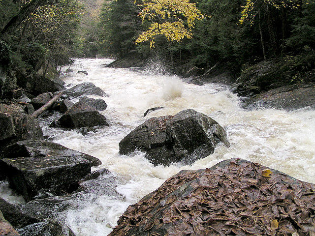
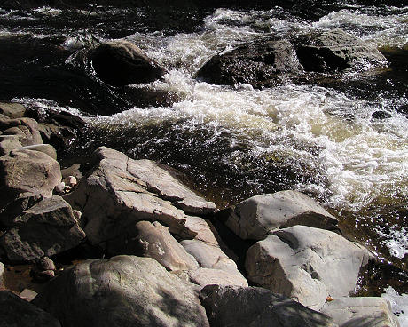
Here, the rapids became undoubtedly beyond my ability to kayak, and at times the shore was tight to the water, and the water so deep and violent that you couldn't wade it. Quicker than I thought we would we arrived at the gorge leading up to Auger Falls. At that point there was no choice but to climb up the bank away from the river, as class IV water ran directly into 30' high sheer cliffs. In no time we were 80' above the river directly: if falling off didn't kill you the ride down the rapids probably would finish the job. It's a pretty bizarre place. As we descended back down into the one spot near the base of the falls that was accessible, we noticed a patch of rainbow created by the spray as it floated up into the sunlight. Beautiful!

Postscript (4th October, 2022)
Nice to see little has changed. This is as incomplete as most of my work!
From my memory, the walk back was uneventful. The old roadbed trail is nearly flat, passing through what is typical damp west-central adirondack forest. What I do recall is how nice it was to do this entire hike with my oldest daughter willingly coming along. Our offspring has since spread out around the continent (and at times, the planet), so we get to see them less and less often. Memories like this help when we miss them most.

Monday, October 17, 2005

Motley Adventures

Things We Do

Lastest Outing The weather stanketh (for the tenth day in a row), but after church Dave G. was waiting for me despite the threatening sky and heavy winds. We wandered southwestward along Route 8 to an easily-missed sharp turn onto a narrow dirt road that shortly crossed a one-lane bridge over the East Branch of the Sacandaga River, right at Griffin Falls. Parking by the bridge, we walked briefly upstream to tour some of the ruins of Griffin itself before heading away from the river downstream for about a mile and a half, on an old road. Posted high on a tree beside the road, a sign warned of the
Dangerous Gorge Ahead
giving notice of our approach to Auger Falls, just in case we were deaf. With the week long supply of rain, you could hear the cataract from a quarter mile away. Dave wandered off the left side of the road and followed a footpath down toward the water. At this point the river tumbles up against the bedrock, perpendicular to the bedding plane and almost head-on with its strike. Forced to make a near-about face, the river then tumbles along parallel to the bedding, where it has cut a deep channel through the next quarter mile. The falls proper begins just after the turn, where the river runs violently into the right side of the channel and then drops about 5 meters, creating a spiral twist in the water as it does so, thus presumably its name. It continues downward in full-froth, crashing over a second drop of perhaps 4 meters and then rampaging downstream through a series of smaller, violent steps and slopes before bending away leftward out of sight. I believe I've seen a photograph of someone kayaking this stretch, but this day that wasn't an option: the river was flowing easily 3+ times as much water as normal. I estimate 600 cfs. (update: probably wayy off...the closest measure I could find was downstream after the junction of all the branches, in Hope: the total flow at that time Sunday was about 4500 cfs; I'm guessing the the middle contributed a third of that). After exploring around the area as best we could, we walked back to the car, acquiring a lift from the cabin-owner by the gate back to the bridge in order to save some time. We then headed onward toward Snowy Mountain. Of course, with the suspect weather, an ascent of that peak was out of the question, but I did want to show Dave the Oddball Boulders, which is a short easy hike. Parking by the cable guardrail, my memory wasn't perfect (what a shock, right?) but we found the blue blazes easily enough. There were plenty of new blowdowns, a few very new ones, which gave us pause about our jaunt - 30kg chunks of dead beech limbs would not feel good - but onward we went. Shortly we climbed along the side of a hill, passed a small wash and up into the area of pockmarked boulders. They were still there, of course; though the coolest boulder has lost most of its thin shell. Perhaps some unlucky boulderer tried cranking on 1cm thick rock and had a shocker, who knows? There is plenty of chalk-mark evidence of climbers playing around on these things. Dave was impressed with them and just as in the dark as I (and Isaakson, I'm told) as to their cause. The vast majority of pockmarks occur on the undersides of overhanging sections of boulders in a fairly restricted area. Outside of perhaps a 100 meter diameter zone, there are few if any; within it almost every overhanging piece of boulder has them, a few have pockmarks in pockmarks in yet more pockmarks, a sort of fractal set of pockings. We took a few pictures, explored around a bit to delineate the region, then headed back to the car and retraced our way to Route 8, where we stopped for one last stroll among the ruins of Fox Lair. By this time alas, it was too dark for photos. It was interesting however, finding a derelict Olympic-sized swimming pool in the woods as well as miles of carefully-laid stonework beside old carriage roads and stone steps leading to several nowheres. Overall a great afternoon exploring several places I've always wanted to look at but hadn't yet, as well as showing off one I had to Dave. Thanks for the lift!